THE EIGHT MOST DANGEROUS HIKES IN ACADIA NATIONAL PARK
1. THE PRECIPICE
People have been attempting to climb up its shear face dating as far back as the mid 1800's when in 1853 two young 12 year old girls attempted to scale it - long before there was an official trail in place. They got three forths of the way upwhen one of the girls, LUCREATIA K. DOUGLASS, stood upon a boulder and looked out toward Schooner Head. The other girl attempted to join her on the boulder when it gave way, tossing one girl to the side with minor injuries, and carrying Lucreatia down over the cliff to her death.
 |
In 2012 a promising college student, Shirley Ladd fell from a ledge to her death, and others have also suffered the same fate. Anyone considering this climb should at least pause a moment by the large sign shortly into the climb that tells of the dangers ahead and that people have been seriously injuried and even killed on this trail. The trail is not for anyone who has problems with heights or walking along very narrow ledges, and using hand rails and ladders to get to higher points may also pose a problem to some.
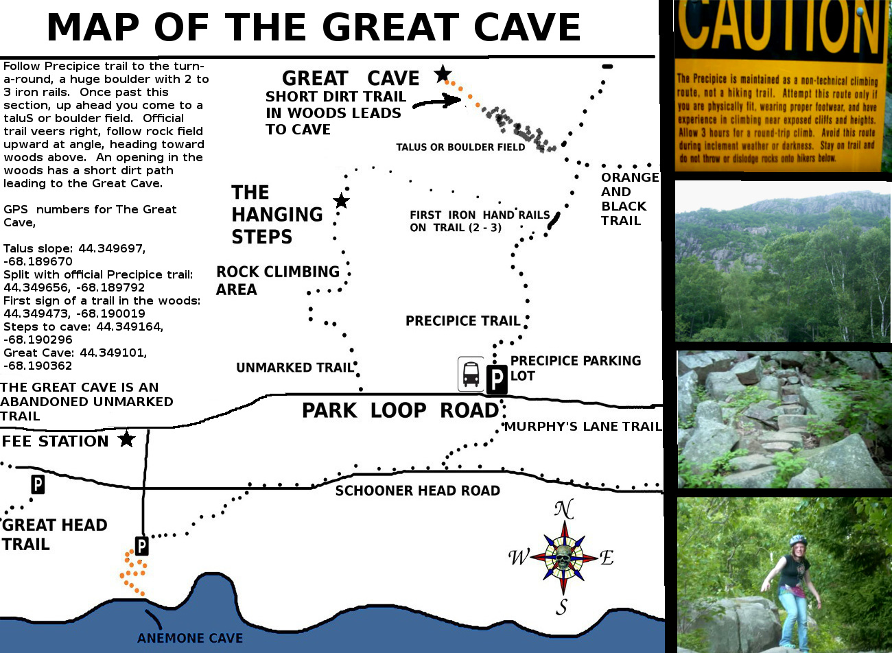
2. THE GREAT CAVE
There has been at least one death in the area of the Great Cave, a young man who was free climbing and fell, and some minor injuries along the unmarked trail such as a broken ankel.

The Great Cave Trail is an abandoned trail and is not marked nor maintained by the Park Service. For a safe trip, caution should be used on this hike.
3. THE BEEHIVE
I believe early into the climb the Beehive has the same kind of sign found on the Precipice trail warning hikers that this is a climb, not a hike, and that people have been seriously injuried and even killed on this climb. These signs were not placed there because the Park Service had nothing better to do, most will climb these areas and have the time of their life, but it only takes a mis-step to go from a great day to a really bad day - these trails are unforgiving.
Someone once asked a ranger where they take people that have a fall on the Beehive or Precipice, the ranger responded, to the ballfield. The visitor though he was joking, and he quickly added, we bring them to the ballfield where a lifeflight helicopter lands and picks them up...we do this because most falls in this area tend to be life threatening.
How often does lifeflight land at the town ballfield - nearly every day throughout the summer and fall.
The trailhead is directly across the road from the Sand Beach parking lot on the Park Loop Road.
4. THE ORANGE AND BLACK TRAIL
This trail was first named the Orange and black Trail than changed to the East Face Trail - in recent years the Park service has once again renamed it the Orange and Black trail. Most people will hike this trail with little problem, but keep in mind there are more than enough places where a mis-step could turn a good day into a really bad day. One end of the trail starts up along the Precipice trail, the other end is along the Park Loop road but very easy to miss. Park at the Precipice parking lot and walk back in the direction you came until you come to the trailhead. This trail contains many stone steps.
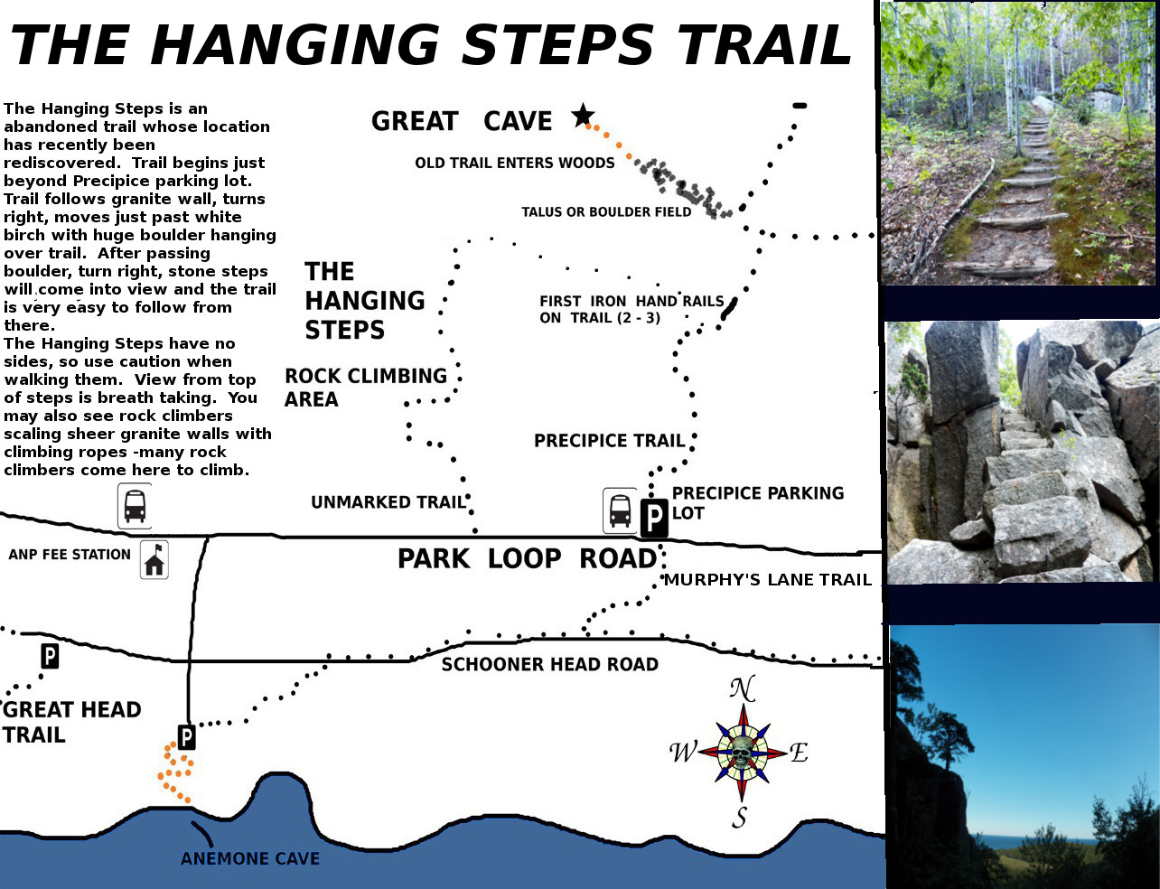
5. THE HANGING STEPS
I do not know much about the past history of the Hanging Steps as far as injuries or deaths go, but from hiking it I can tell you there is more than a few places where I could see someone getting injuried or even falling off a cliff. The trail is an abandoned trail today, unmarked - but many years ago was a very popular trail most famous for its hanging steps which appear to hang in mid air. The trail begins just beyond the precipice parking lot at a worn unmarked trail that enters the woods. You quickly come to a signup post meant for rock climbers from the local rock climbing schools.

The trail ends at a lower section of the Precipice trail, the section known as the turn around. It got its name because the Park service designed it in a way as to make inexperienced hiikers turn around and head back to the parking lot, and usually once hikers come to the huge boulder with the two hand rails, they do just that, turn around. Oh, and in the days when this was an official trail, it was once park of the Orange and Black trail.
6. ANEMONE CAVE
The Anemone Cave trail is a short hike through the woods which quickly ends at high cliffs overlooking the ocean, but its not the short hike where the danger lies, its in first reaching the cave entrance, and than exploring inside the cave where the danger lies.
From the Schooner Head Parking lot you walk down a narrow unmarked but paved trail which ends at the cliffs. As soon as you stand on the Cliff, you are standing on the roof of the ancient sea cave, which can only be entered at low tide.

At least one old map named the site "The Devil's Oven", and there are many stories and accounts of people being trapped in the cave as tiny waves outside the cave suddenly became crashing waves, carrying screaming people out to sea. The Park Service says its reasons for abandoning the cave are as follows; too many people were entering the cave at the wrong time and becoming trapped, meaning the Park service had to larnch a rescue. They also site that there were too many injuries at the cave, and also say it was to protect the Anemone which make the tidal pools in the cave their home.
I can tell you this much, when the Park Service removed the iron railings which helped safely guide people down to the cave entrance, that ended up making the site much more dangerous than it had been. Any granite that looks wet will be slippery, keep that in mind. Once the cave entrance is reached, its floor in coated with seaweed which is extremely slippery - so one mis-step could lead to an injury. Walk slow, test your footing, and wear a pair of very good shoes with a good grip on them.
One of the lure's of the cave is that you just don't know what you could find in it...I had a neighbor who found a very large shell which had washed up in the cave, large enough to hold up to your ear and hear the sea in...it was pretty amazing.
When at the cliff, walk out onto the cliff to the right and look down and you can actially see the mouth of the cave at low tide.
I had hoped by the time I had first publiched this piece I would of been able to track down at least one account of someone actually having been trapped in this ancient sea cave - I was not able to, but late last night I finally found n old news story of just that, of two college students getting trapped in Anemone Cave.
In 1993 Douglas Rose and another College of the Atlantic student were rock climbing along the cliffs of Great Head, and had made their way to the ancient sea cave when they decided to do one last climb. They lowered themselved by rodes down to the mouth of the sea cave and went in to do some exploring. Heavy winds suddenly picked up off the ocean, sending large waves crashing into the cave. After a long struggle of battling against the strong waves, they finally managed to get outside of the cave, but it came at a price, both young men were fatigued and suffering from Hypothermia. One of the students was finally able to recover one end of their climbing ropes and was able to pull himself up the face of the cliff, but Douglas Rose had no energy left for the climb and huge waves continued to batter him against the rocks.
after about half an hour of trying to help Douglas, his friend made his way to the Bar Harbor police station for help. A rescue team was assembled but to to darkness, rain, heavy winds and waves, it was decided not to attempt a rescue effort once it was learned that the rope used to secure Mr Rose had been cut free from friction caused by the waves against the granite. The following day when the weather cleared a rescue team was lowered down to the cave, which was still half filled with water, and they found Douglas rose floating face down in the cave.
7. THE ABANDONED LIGHTHOUSE TRAIL
The Bass Harbor Lighthouse Trail is an abandoned trail that is not marked, and appears on some old maps. On foggy days the trail has a haunting feel to it as it passes through woods, along cliffs and the shore, at mid point passing a high cliff over looking a beach below known by locals as Whistler's Beach. It is said the beach got its name from a private land owner who cut his own private trail from his house to the beach, and that when ever he approached the beach he would whistle as he passed through the woods to scare anyone off who may be in the area.
Some have reported seeing strange lights in the sky around Whistlers beach after dark, and hearing strange sounds coming from the nearby woods. Some even claim the old trail is haunted...you been warned.
Once past Whistlers Beach the trail continues with the ocean in view most of the ways, ending at the mouth of Ship Harbor. As you stand at its mouth and look across you can often see tourists on the other side of the water making their way along the official Ship Harbor Nature trail.

If you are from the area you already know how to get through the woods and connect to the Ship Harbor parking lot, which is what the trail use to do. If not from the area, you might want to return to the Lighthouse the way you came.
The danger in this hike lies in those cliffs and drop offs found along the first half of the trail, you don't need to go close to them and not doing so makes for a safe hike. There is also one hill with one side being steep, continue down it slowly. the further you go the more places you find driftwood washed up on the shore and there are a number of places you can get out of the woods to the water for some great photos.
To find the unmarked trail you need to begin at the Bass Harbor Lighthouse parking lot. Go the far far left of the parking lot by hte restrooms, a path enters the wood, turns the corner and straight ahead is a steep wooden staircase which takes you below the lighthouse. The trail begins just inside the woods before that wooden staircase.
8. THE GREEN MOUNTAIN RAILROAD TRAIL
The Green Mountain Railroad trail did not begin as a trail, it was the route that the cog train once took from eagle Lake to the summit of Green Mountain (now named Cadillac). The railroad company went out of business and the rails were removed and sold for scrap, all but one, that is. That single piece of rail still sits on the mountain side half way up the trail. The iron railroad spikes had been driven so deep into the granite most could not be removed and mark the route the train took to this day.
There is only one real danger along this trail - the wet sloping granite near the top section of the trail, it is usually extremely slippery due to the over flowing water from a nearby brook. I know of one hiker who sliped and fell there and ended up with cuts and a knee injury, and I have had a number of close calls.....if the ground or granite looks wet, make your way around it to stay safe.
To reach the area of the trail, drive past the entrance of the Cadillac Summit Road, you will quickly come to a pull over as you head toward Bubble Pond and Jordan Pond. Drive past the first pull over and stop at the second pull over.

Standng at the center of the pull over, the train tracks once passed right through where you are standing. You will not see any railroad spikes near the roadway, the lower section runs along the bottom of a gully which begins several car lengths down the banking beyond the brush.
The upper section begins across the roadway, go up the banking and slightly to the left and begin to look for worn earth, a spike sticking up out of the ground or rock piles. From there the trail goes straight ahead, the further you go, the easier it is to follow with many railroad spikes higher up.

