The most dangerous places in the world
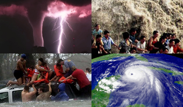
Until recently, the U.S. was hurricane season, a time of year when vulnerable residents to be cautious, to take cover and prepare for the unexpected. In the world there are many places where threats are at least as large and hard to believe that there are people willing to inhabit and live constantly in fear of Mother Nature's whims.Following is a list of such ... destinations around the globe that require luck, resources and more faith in themselves to survive year after year.
Frozen Pole - Verkhoyansk, RussiaA monument on which is written "Polyus Cholada" in Russian version of the formula "cold pole", marks the entrance to the town of Verkhoyansk. In frigid taiga, a distance of nearly 5,000 kilometers from Moscow, deep in the heart of Siberia, is this frozen place: the oldest city above the Arctic Circle. For more than three centuries, siberienii constantly live here, facing the man endless winters on the banks of the River Yana frozen completely frozen for nine months a year. Currently, about 1,500 people take their daily existence in Verkhoyansk, the coldest city ??in the world. Between September and March, the city enjoys less than five hours of sunlight each day (in December and January it almost does not exist). Winter temperatures drop to -40 and even up to -50 degrees Celsius.
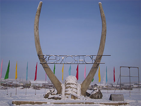
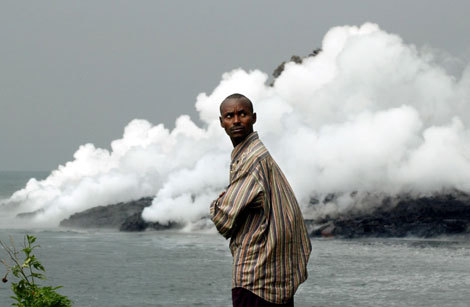
The lowest temperature ever recorded was -67 degrees Celsius, and it happened towards the end of the nineteenth century. Nowadays, the city is trying to attract "tourists amateur extreme cold leaned heavily". However, for long history, Verkhoyansk was an exile destination, used initially countries, and then the Soviet regime for undesirable people. In the twentieth century, the city's population reached an absolute maximum of 2,500 residents. Fire Mountain - Mount Merapi, Indonesia Even in the quietest period Merapi volcano, on the island of Java, smoking. Smoke rises continuously from the furnace up to 3,000 meters in the sky."Mountain of Fire", as translated natural monument designation has erupted about 60 times in the last five centuries, most recently in 2006. before this episode, an eruption in 1994, ejected a cloud of hot gas lethal which 60 people burned alive. Also in 1930, more than 1,000 people have perished when the Merapi lava showered with an area of approximately 20 square kilometers around the base of the volcano, carnage being produced because of the fact that too many people lived too close to the mountain.
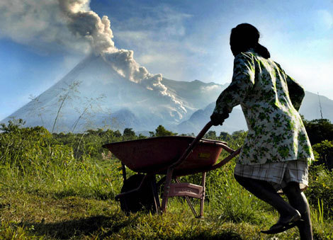
However, despite this bloody history, approximately 200,000 villagers living today within a radius of 6-7 kilometers away from Merapi. They are not the only Indonesian forces his luck in proximity to active volcanoes - it is estimated that 120 million of the 136 million residents lead their lives based Java has 22 active volcanoes. Haiti's perfect storm - Gonaives, Haiti First came Tropical Storm Fay on 16 august. A week later, Hurricane Gustav hit staggering. In quick succession, followed urganele Hanna and Ike. During a single months, the coastal city of Gonaives, one of the five largest cities in Haiti, was found ravaged by four devastating tropical cyclones. After the last storm passed, Gonaives was basically thrown into the sea. Much of the city was buried under mud or submerged in filthy water with depths up to 3.5 meters in some places. The death toll approached 500. august But storms to September 2008 were the deadliest in recent history the city Gonaives. In 2004, the town with 104,000 inhabitants received the most deadly effects of hurricane Jeanne. Three thousand Haitians died when the storm hit cateogoria 3 of the island.
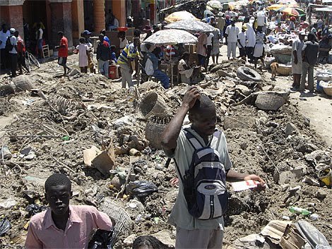
What makes Gonaives likely to be so destroyed by the hurricane? Except positioning coast in the Gulf of Gonave, the Caribbean, prone cyclone hits, Gonaives rests on a steep plateau where water drains flooded when rivers swell. Moreover, Haitians rely on wood to get charcoal, their main source of fuel, and this has led to massive deforestation of the hills surrounding the city. As a result, when it rains, the hills surrounding Gonaives slide downhill and piles of mud almost buries the city. African Lake of Death - Lake Kivu, Democratic Republic of Congo / Rwanda Lake Kivu, located on the border between Congo and Rwanda, is one of the Great Lakes of Africa. Deep below the surface of 7,000 square kilometers, lie 65 million cubic meters of natural gas, along with 250 cubic kilometers of carbon dioxide trapped in the lake water and ground pressure. If would be released from the depths, these gases could spread a cloud of death of over two million Africans living in the basin of Lake Kivu. precedent that feeds a serious concern in this respect lies in a pair of events occurring in the years 80 In two other African lakes having similar chemical compositions. In 1984, 37 people died around the lake Cameroon Monoun in an eruption of carbon dioxide. Three years later from Lake Nyos, also in Cameroon, 80 cubic meters of CO2 were released. Subsequently, 1,700 people died as a result of exposure to toxic gas.
These incidents were apparently caused by volcanic activity beneath the lake, which would have triggered deadly flooding. An activity asemenatoare it seems that there are in Lake Kivu, many geologists saying that this area would be next on the list. A report by the United Nations Environment Programme three lakes called "Africa's Killer Lakes", noting that Lake Kivu is cause for "serious concern." ephemeral Islands - Maldives Maldives is a place so dangerous that Mohamed Nasheed, President republic in 2008, and chose the main goal of his tenure raise funds for financing the relocation entire island population. Maldives is a confederation of 1190 islands and atolls in the Indian Ocean. Point of maximum altitude of Maldives rises less than 1.8 meters and sometime not so distant future, they are likely to be completely swallowed by the ocean waters more expansive. A 2005 estimate of United States Geological Survey, made following the tsunami brought Indian Ocean shores in 2005, decreed the Maldives as one of the youngest land masses of the world, adding that they are not meant to have a life too long over the water. According to the report, the islands "should be considered ephemeral elements in geological time."
According to President Nasheed, Maldives islanders will be well nourished to find a place to live elsewhere - India and Sri Lanka have been suggested as potential refuges. Events them argue the decision to invest money earned through tourism in relocation funds: the 2004 tsunami that swept islands, made ??10% of the country uninhabitable.Then, from the 300,000 citizens of the Maldives, one third remained on the road, and over 80 people died. Also in 1987, during the so-called "royal flows", the capital Male, an island city on an area of 2.6 square miles, was completely flooded. hurricane capital of the world - Grand Cayman MODIS instrument on board NASA's Aqua satellite captured an image of Hurricane Ivan sensational color while his eye is above the Cayman Islands on September 13, 2004. Cayman Islands, a British territory located 240 kilometers from Cuba, are best known as a tropical playground of champagne and caviar lovers who come to the islands for pristine beaches and crystal clear ocean water, but also by virtue of financial legislation very relaxed. However, less tempting remains reputation as "hurricane capital of the world" they have these places. According to the website monitoring tropical storms hurricanecity.com, Grand Cayman, the largest of the three Cayman Islands, is hit or at least a hurricane swept once every 2.16 years, more frequently than any other area of the basin Atlantic. Since 1871, 64 storms have ravaged low altitude limestone formation, often with catastrophic consequences.
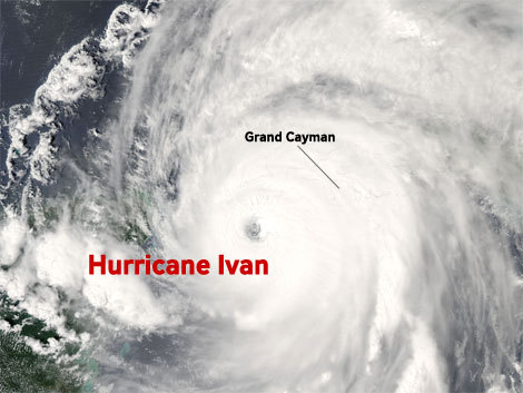
In 2004, Hurricane Ivan, a Category 5 storm with wind speeds atigand 240 km / h, apocalyptic rain swept over the island of Grand Cayman. There was, then, the assault of three meters high waves that sank a quarter of the island.An estimated 70% of the buildings here were destroyed and 40,000 people whom the price remained housed for several days without electricity and without drinking water. tornado corridor I-44 - Oklahoma City / Tulsa Oklahoma Over one million people live within the limits of interstate 44 corridor, located between Oklahoma City and Tulsa, the most populated metropolitan areas of the U.S. state of Oklahoma. Every spring, when cool, dry air of the Rocky Mountains down to the lower plateaus and the hot and humid air from the Golgi coast up north to meet the people who live along this route, called Tornado Alley local, preparing for hurricane season. since 1890 until today, more than 120 tornadoes struck Oklahoma City and surrounding area, who hosts, currently about 700,000 people. On May 3, 1999, a host of 70 tornadoes swept the states Oklahoma, Kansas and Texas. Some of the most destructive storms ransacked when Oklahoma City, causing the destruction of 1,700 houses and damaging other 6,500. Even with modern prediction capabilities and early warning systems, 40 people died when a cyclone swept F-5 Oklahoma City. In addition to loss of life, this display of nature's forces caused distugeri worth over a billion dollars.
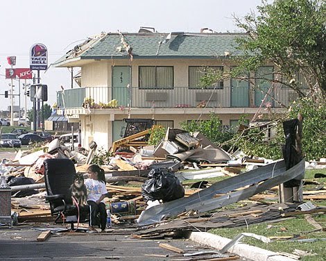
Since 1950, the longest period in which the I-44 corridor was not hit by a tornado is five years - from 1992 to 1998.As a rematch of the rest, in the 11 months following this period, 11 tornadoes struck suddenly. For only three other times in the past half century has been more than two years without a tornado in Oklahoma City. In northeast of the city, along the same route "tornado-fil" is Tulsa, who had hand, Radul or a portion of seriousness storm devastation in Tornado Alley. Between 1950 and 2006, 69 tornadoes ravaged city with a population of 590,000 inhabitants, although none was as devastating consequences as those of deadly storms occurred in 1999 in Oklahoma City.But because of its geography, the city is located along the Arkansas river, and thus built up a large number of small estuaries, Tulsa is particularly vulnerable before rains that accompany storms in Oklahoma. Major floods in 1974, 1976 and 1984 caused damage worth hundreds of thousands and millions of dollars. Sandbox China - Minquin province, China constrained by two expansive deserts, oasis that was once fertile land of Minqin, north- western Chinese province of Gansu has literally counted the days. Double misfortune of a long drought a decade and diversion, upstream from the Shiyang River has fiersc, Minqin forced to decay toward the Tengger desert, approaching from the south-east, and toward the Badain Jaran Desert, the " attack "from the northwest. Overall, in 1950, two deserts have swallowed more than 250 square miles of territory Minquin community. Interestingly, during the same period, the population grew from 860,000 to place people at over two million. Since 2004, the desserts have advanced ten meters each year. With over 130 days with dust storms every year, slowing the advance rate is unlikely.
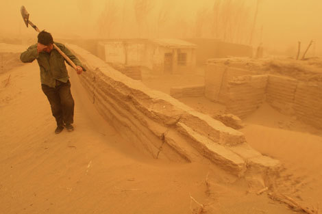
Experienced an accelerated desertification, the Chinese government has begun relocating farmers uprooted, given that arable land in the region fell by over 750 square kilometers from 930 square kilometers to less than 155 square kilometers.
You've added this content to your favorites.

Post your comment
Load More
